Steps to success for hiking in Baxter.
Find your trail
We have 220+ miles of trail, only 16% of which are on Katahdin. There is much more to see in these 209,644 acres, and you won’t have as much company on the other 40+ mountain peaks in the Park. Explore!
Hiking the Appalachian Trail? Find more here about how to FINISH WELL…
Basic Trail Maps (available for download):
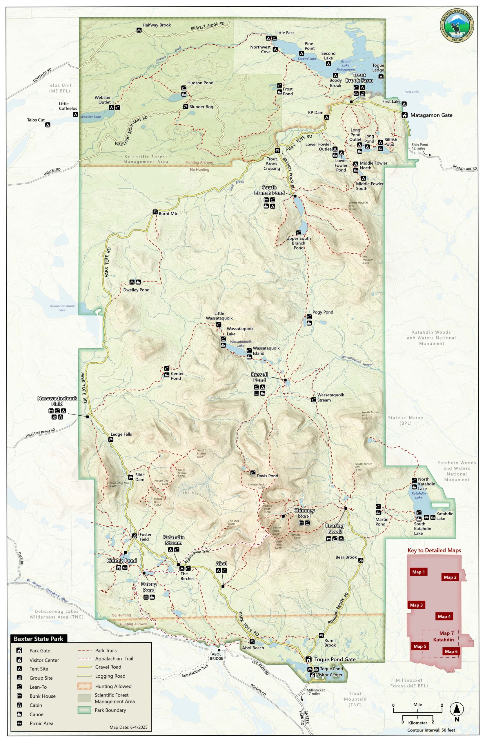
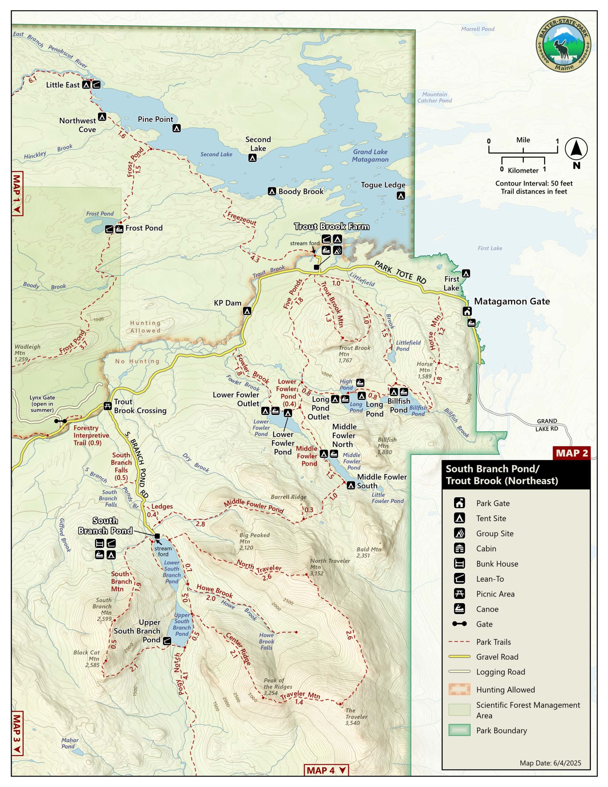
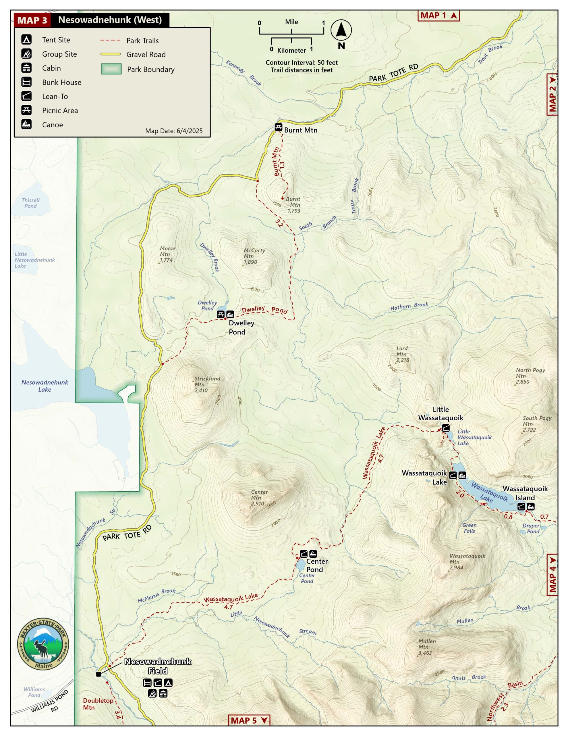
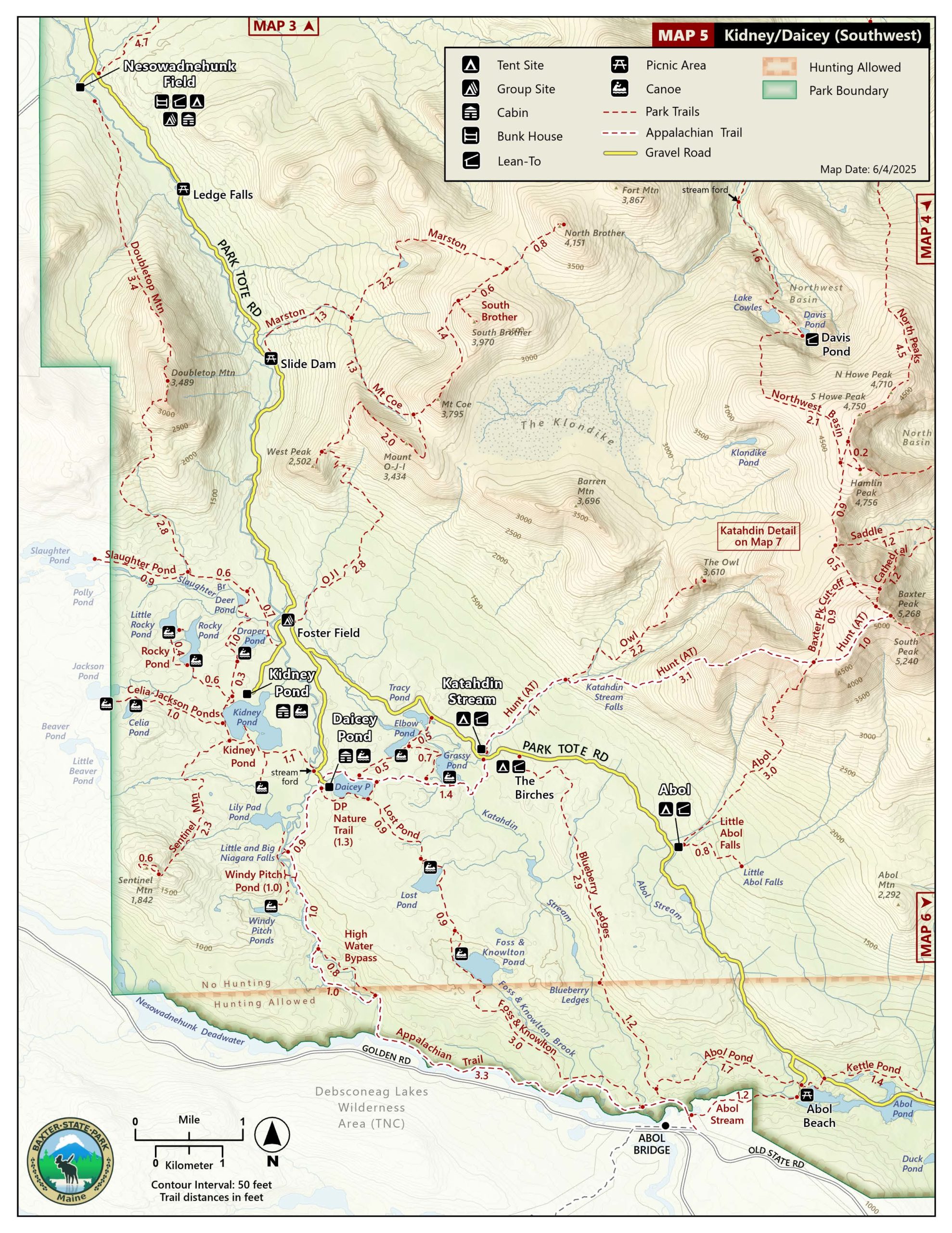
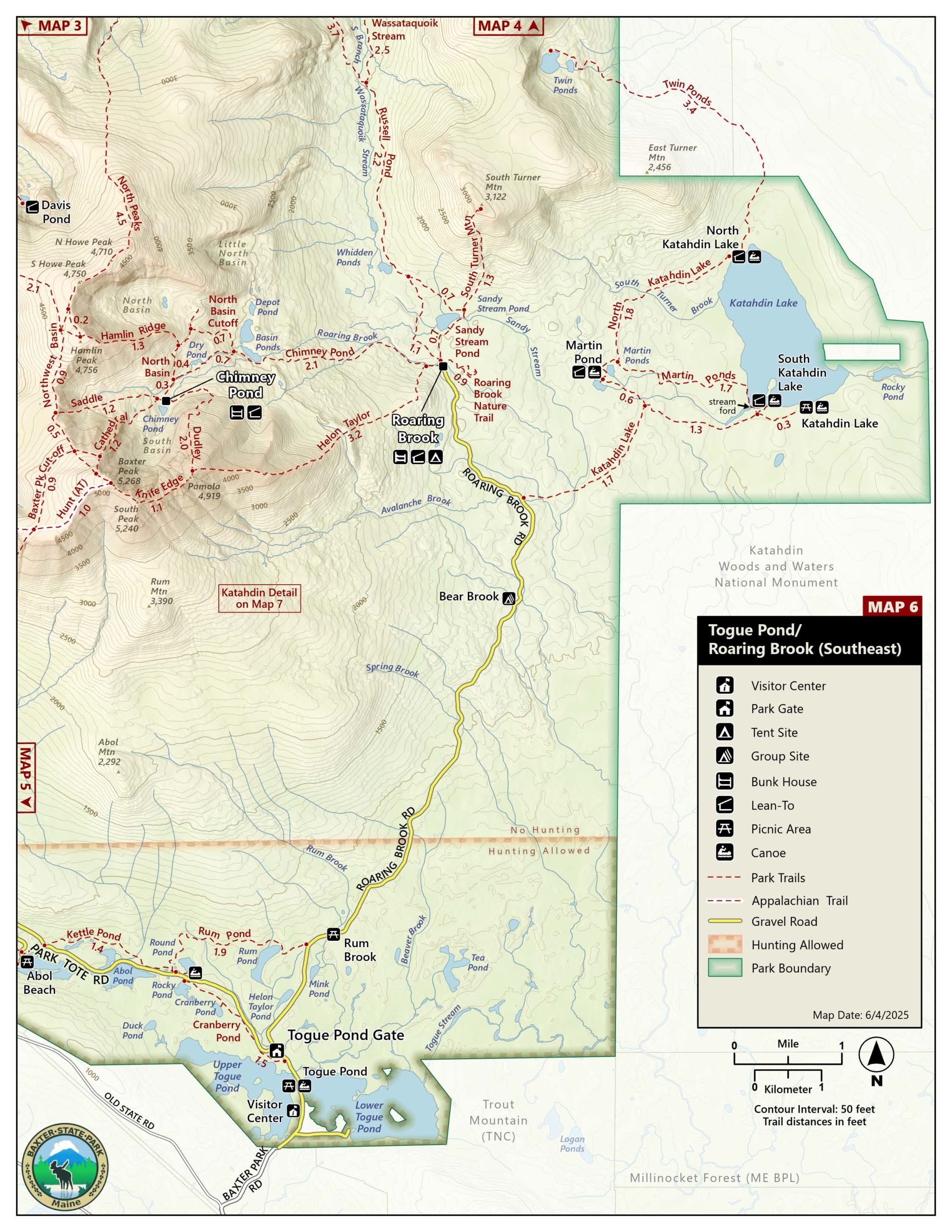
For additional maps, visit the store
Or, download our maps in the Avenza maps store
(within the app, go to the map store and search for Baxter Park)
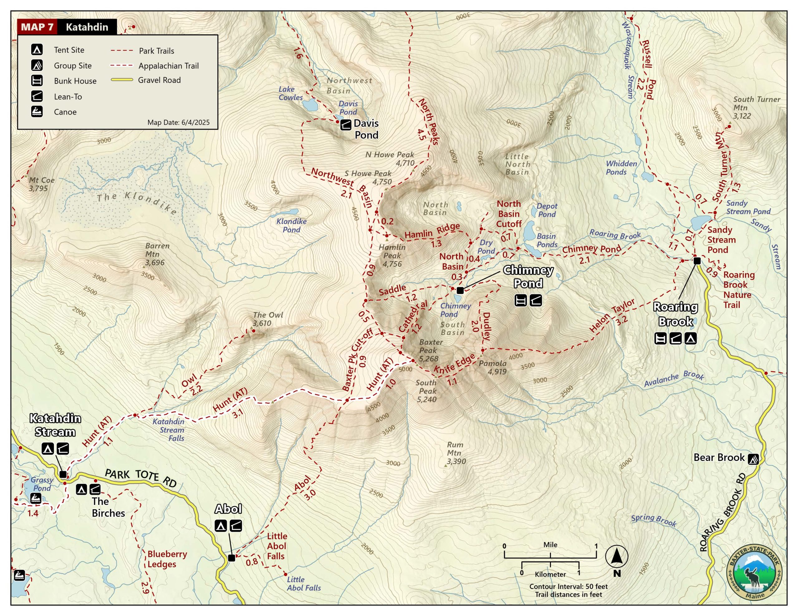
Katahdin Trail Descriptions
Hiking Katahdin requires an elevation gain of around 4,000 ft. This is a very strenuous climb, no matter which trailhead you choose.
The average round trip time for a Katahdin hike is 8-12 hours.
The park is open for day use from 6:00am to 10:00pm.
For more in-depth trail descriptions, we publish our own trail guide.
We limit access to Katahdin to protect natural resources and a wilderness experience. We do this by limiting vehicles at the three roadside Katahdin trailheads. You can reserve a parking spot at these trailheads through our reservation system. We highly recommend this especially for July and August as well as most weekends–space is limited and can fill up fast. See below.
Download trail head map.–>
3.4 miles (plus 1 mile on Hunt trail 4.4 miles total one way to Baxter Peak) Elevation gain 3,982ft
This trail is the shortest route to Baxter Peak from a roadside trailhead. The trail formerly utilized the prominent Abol Slide, but was relocated in 2015 after soil and rock movement on the slide increased the hazard to hikers. The relocated trail uses the ridge to the west of the slide and provides a steady, but steep ascent with excellent views. Water is limited after the first mile and the trail is fully exposed after 2.5 miles. On warm days, an early start is recommended. Once on the Tableland you will connect with the Hunt trail (AT) for the last mile.
Difficulty level: Very Strenuous
Trailhead Parking lot: Abol Campground
<– Download trail head map.
5.2 miles one-way Elevation gain 4,188 ft
The Hunt trail is one of the more popular trails to the summit of Katahdin. This is because of the outstanding features along the trail such as picturesque Katahdin Stream Falls, the Boulders on Hunt Spur, the traverse of the Tableland, and extensive views in all directions, as 2.4 miles of the trail is above tree line.
Difficulty level: Very Strenuous
Trailhead Parking lot: Katahdin Stream Campground
Download trail head map.–>
3.2 miles one-way Elevation gain to Pamola Peak 3,413 ft
This trail allows hikers to have a direct route from Roaring Brook trailhead to connect with the Knife Edge trail at Pamola Peak. It is an extremely exposed trail and because of this, hikes should not be attempted in bad weather.
Difficulty level: Very Strenuous
Trailhead Parking lot: Roaring Brook Campground
2.0 miles one-way Elevation gain to Pamola Peak 1,988 ft
This trail leaves from Chimney Pond campground. It is a short, very steep climb to reach Pamola Peak. This trail is almost entirely above tree line. No water available on this trail.
Difficulty level: Very Strenuous
Trailhead Parking lot: Roaring Brook Campground
Download trail head map.–>
1.5 miles one-way (1.7 miles to Baxter Peak) Elevation gain to Baxter Peak 2,353 ft
The shortest climb from Chimney Pond to Baxter Peak. To reach the peak, it utilizes the Saddle Trail for an additional 0.2 miles. It is very steep climbing over three large rock buttresses. The climbing is almost all above tree line. There is no water on this trail.
Difficulty level: Very Strenuous
Trailhead Parking Lot: Roaring Brook Campground
<– Download trail head map.
2.2 miles one-way Elevation gain to Baxter Peak 2,353 ft
This trail is the most gradual ascent. Reach Saddle Brook at 0.8 miles from Chimney Pond campground. This is the last sure water. The most difficult section on this trail would be the 0.2 mile slide right before encountering the Tableland. Hikers should expect to encounter difficult footing, loose stones and gravel on this section of trail.
Difficulty level: Strenuous
Trailhead Parking Lot: Roaring Brook Campground
Download trail head map.–>
1.1 miles one-way Elevation gain hiking from Pamola Peak 365 ft (If hiking from Baxter Peak descend 365 ft)
This route is completely exposed and several people have died or have been seriously injured while attempting a traverse in inclement weather and/or high winds. Do not attempt to leave the ridge once you have started. Hiking Knife Edge across and back is not recommended due to its difficulty and the amount of time it adds to the hike – it takes approximately 1 to 1½ hrs. one way. Access to Knife Edge is from the Roaring Brook Campground. Hiking it from the Hunt or Abol Trails means ending at Roaring Brook Campground, an hour by road from your vehicle on the other side of the mountain. We do not provide shuttle service. There is no water on this trail.
Difficulty level: Very Strenuous
Trailhead Parking Lot: Roaring Brook Campground
<– Download trail head map.
1.5 miles one-way Elevation gain 1,837 ft
Hamlin ridge is a long open ridge, which offers outstanding views. The trail begins on the North Basin Trail 0.7 miles from Chimney Pond Campground. It then ascends a long ridge to Hamlin Peak, descending to its terminus at Caribou Spring and at the junction of the Northwest Basin Trail. This trail does not access Baxter Peak. You can make a 4.5-mile loop hiking to Hamlin Peak, then following the Northwest Basin Trail back to the Saddle Trail, descending to Chimney Pond Campground.
Difficulty level: Strenuous
Trailhead Parking Lot: Roaring Brook Campground
Download trail head map.–>
3.3 miles one-way Elevation gain 1,425 ft
This trail takes you directly to the Chimney Pond Campground. The Helon Taylor trail leaves the Chimney Pond Trail after the first 0.1 mile. Chimney Pond Trail hike starts gradual and becomes a moderate hike. Some sections are steep and most of the trail is covered in rock. Plenty of water sources on this trail.
Difficulty level: Moderate
Trailhead Parking Lot: Roaring Brook Campground
<– Download trail head map.
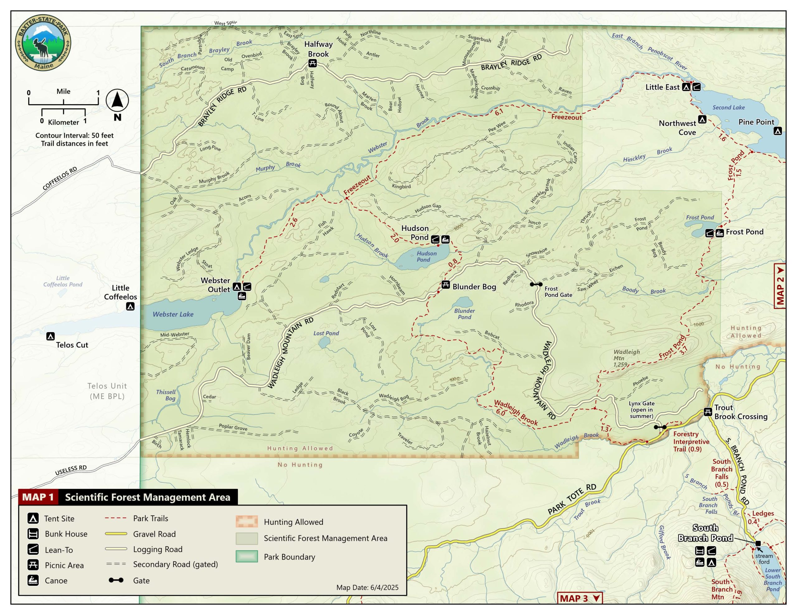
The Traveler Range is not part of Katahdin. It is found in the north end of the park, but offer hikes that are similar in difficulty to a Katahdin hike. The Traveler Loop combines four trails that provides an extended hike of more than 10 miles, that includes a three major peaks and extended hiking above treeline.
The trailhead for the Traveler Loop is South Branch Pond Campground. This campground is best reached via the Matagamon Gate at the northeast corner of the Park. No parking reservations are necessary for this trailhead.
The Traveler Loop begins with the Pogy Notch Trail (1.5 mi.) and then follows the Center Ridge Trail (2.1 mi.), continuing on the Traveler Trail (3.7 mi.) and finishing with the North Traveler Trail (2.6 mi.). The Traveler Loop summits three peaks, Peak of the Ridges, The Traveler and North Traveler Mountain and the hike requires a total elevation gain of 3,700 feet, only 400 feet less than required of a Katahdin hike on the Hunt Trail.
The loop can be hiked in two directions, but we recommend the loop be traversed in a counter-clockwise direction, ascending the Center Ridge Trail from Upper South Branch Pond. After leaving the Pogy Notch Trail along Upper South Branch Pond, water is scarce to non-existent on the Traveler Loop. We recommend that hikers carry at least 2 quarts of water per person and more on hot days. This is a strenuous and long hike with extended exposure above treeline, so hikers should be aware of changing weather and prepared for a beautiful, but demanding hike.
Preparation for a Traveler Loop Hike is the same as a Katahdin hike.
Easier Day Hikes
If you’re short on time or not up for a big push above treeline, you might try some of these short hikes on Maine Trail Finder.
Or try some suggestions based on the amount of time you have to spend:
If you have 2 hours, entering and leaving via Togue Pond Gate, we suggest:
- Cranberry Pond: This little gem of a walk starts within sight of Togue Pond Gatehouse and winds through the forest to arrive at a small pond with all sorts of bog plants, from cranberries to tiny sundew plants! Stay on the bog bridges to protect the plants and keep your feet drier! (Maine Trail Finder)
- Togue Pond rental canoe: Employees at the Visitor Center or Togue Pond Gate can rent this canoe, life jackets and paddles for only $1/hour! Paddling on either of the Togue Ponds is a great way to “preview” the Park, especially Katahdin, which dominates the view on a clear day. A picnic and short dip in Togue Pond will make the perfect summer afternoon!
- Caverly Pond: Parking for the short trail to this pond can be found about 1 mile from Togue Pond Gatehouse on the Park Tote Road. Katahdin seems to loom straight up from the far shore of the pond and if you approach quietly, you may see one of the resident deer near the pond edge. (Maine Trail Finder)
- Abol Pond Picnic Area: Do you like to share your picnic spot with loons? Abol Picnic Area is reached by taking the signed spur road on the left 3 miles from Togue Pond Gate. Proceed past employee housing down the hill to the end of the road. Shelters over the tables make this a good choice if it is raining. Little ones will enjoy the tadpoles and dragonflies at this location!
- Mobility limitations? We suggest you visit Abol Pond culverts and Stump Pond. The Abol Pond culverts are approximately 2.5 miles from the gate with Abol Pond on both sides of the road, photogenic views of the mountain and a productive wetland with abundant wildlife; keep your eyes open! Stump Pond is about 2.5 miles further down the road. There is a parking area with a short trail across the road to a viewing platform.
If you have 4 hours, entering or leaving via Togue Pond Gate, we suggest:
- Daicey Pond: The campground spur road leaves the Park Tote Road 10.4 miles from Togue Pond Gatehouse. Park in the designated day use parking lot. Walk up the hill to find the campground with rental cabins. You have just enough time to hike down to Big and Little Niagara Falls about a mile walk down Nesowadnehunk Stream from the campground. Alternatively, rent a canoe or kayak and paddle around the small pond with extraordinary views of Katahdin. If you have small children who need to be active, you may want to hike around the entire pond; pick up a guide for the Daicey Pond Nature Trail and learn while you hike!
- The Kidney Pond campground spur road leaves the Tote Road north of the sign for the Daicey Pond spur road, winding through bottomland forest and over Nesowadnehunk Stream into this campground. There is a spacious open picnic area and canoes for rent. A 0.6 mile hike will bring you to Big Rocky Pond, with Little Rocky just beyond. Check with the local ranger to see if the rental canoes at these ponds are available.
- Katahdin Stream Falls: Katahdin Stream Campground is the second campground you come to on the Park Tote Road, about 8 miles beyond Togue Pond Gatehouse. Warning: Because this is a trailhead for the Hunt Trail up Katahdin, the parking lot here may be filled for the day; gate attendants will help you to choose another hike. The hike to Katahdin Stream Falls is about a mile of gradually uphill forest hiking, leading to a bridge across the foot of the falls and several viewpoints uphill, along the side of the falls. The trail here is white-blazed because you are hiking a portion of the legendary Appalachian Trail, which ends (or starts, depending on which direction you are hiking) at Baxter Peak on Katahdin!
- Sandy Stream Pond: Head to Roaring Brook Campground, 30 minutes from Togue Pond for this ½ mile hike Roaring Brook is the most popular Katahdin trailhead so parking spots are often taken very early in the morning. Togue Pond Gatehouse issues “Moose Passes”, good for three hours per pass, on a first-come, first-serve basis. While luck is a big part of wildlife watching, it also helps to approach the pond quietly and keep your voices low when you are in this area. Please check elsewhere on this website for Wildlife Watching guidelines to observe, especially when in “Wildlife Area Only” zones.
If you have 2 hours, entering/leaving via Matagamon Gate, we suggest:
- Horse Mountain: The trailhead is 0.6 mile from the gatehouse. The trail is steep but within 1.2 miles, you will see a sign for a spur trail to the viewpoint. This is well worth your time. Take a snack and water with you as well as your camera. You will have a birds-eye view of Grand Lake Matagamon and speaking of birds, you may be sharing the view with numerous Turkey Vultures that have been roosting on the cliffs of Horse Mountain in recent years. These birds are masters of the thermals and typically ride the updrafts of warming air in late morning in ever-widening spirals.
- Trout Brook canoe exploration: Trout Brook Campground is 2.6 miles west of Matagamon Gate on the Park Tote Road. Canoes are located near the Group Camping Area, on the bank of Trout Brook. Life jackets/ paddles are stored on the porch of the ranger cabin and rental is $1/hour. The launching area can be slippery. The current here is gentle but steady as you float out toward Matagamon Lake. Wildlife abounds, ospreys and great blue herons fly above you and ducks and geese forage while a moose may be feeding out closer to the lake.
If you have 4 hours, entering/leaving via Matagamon Gate, we recommend:
- South Branch Pond Campground: Allow thirty minutes to drive from the gate to the South Branch Campground road and into the campground. On the way, you will pass a small parking lot for South Branch Falls. A short walk from the car will bring you to dramatic tilted rock exposures and fast flowing water of the Falls, a perfect rustic picnic area. Near the campground, you will see the day use parking lot. You can choose to hike the South Branch Nature Trail with the self-guiding pamphlet, take a shorter hike to visit just the Ledges viewpoint over the ponds or picnic in the public picnic area near the water. Canoes and kayaks are for rent here under the same system as the rest of the Park: $1/hour with paddles and life jackets. A paddle on Lower South Branch is an excellent way to view and plan for future trips up all the mountains easily viewed from the comfort of your canoe!
To Know BEFORE you Come….
Listen to this podcast from “The Maine Show” for tips on how to prepare.
Parking Reservation for Katahdin
If you are day-hiking Katahdin, you may want to ensure your parking spot with a reservation.
Register
Please register at one of the two gatehouses coming in. If you are not a Maine resident, there will be a fee for entrance.
Leave These at Home
Do NOT bring pets, firewood, drones, or more than 12 people per party.
10 (Essential) Things to Pack
download a more detailed list here.
Remember that your primary goal is not reaching the summit, but a safe return to the trailhead.
10 Things to Do
Know and respect the forecast.
Know what to expect, and when it changes, know your limits.
Limit group size to 12.
This is a Park Rule.
Keep an eye on kids.
Park Rule: for every five juveniles, there must be at least one adult.
Pick a Turn-around time.
If you aren’t up by mid-afternoon, chances are you won’t have time to make it down before dark.
Remember going down is neither easier nor faster.
80% of Park search and rescues happen on the descent. Plan at least as much time for the descent as the ascent.
Stay on the trail.
Toilet duties aside, more than 75% of our most serious search and rescue incidents (i.e. fatalities) began when a hiker left the trail.
Sign the trail register.
This helps us to find you if you get lost.
Get a Parking Reservation.
If you’re day-hiking Katahdin, this is the only way to make sure you’ll be able to park.
If you’re camping in the Park prior to hiking, you don’t need one.
Get here early.
It takes a long time to get anywhere in the Park at 20mph. Build extra time into your day.
Turn off your phone.
Treat it as an emergency communication device. Save your battery. Enjoy the disconnection.
To make your BSP experience (and everyone else’s) more enjoyable…
Katahdin Trailhead Passes (KTP)
Why we require Katahdin Trailhead Passes
The Katahdin Trailhead Pass system (formerly known as Day Use Parking Reservations) is an important tool for managing the impact of Park visitors on Katahdin’s alpine ecosystem and its trails, which experience the highest level of use in the Park. The system also prevents overcrowding on the Katahdin peaks and trails, leaving visitors to experience the wild nature of the Park in accordance with Governor Baxter’s wishes.
When is a Katahdin Trailhead Pass necessary?
- A KTP is necessary for all visitors who want to ensure they are able to hike from a Katahdin trailhead if they are NOT camping in the Park the night prior. This includes visitors who wish to hike trails departing from the Katahdin trailheads even if they do not ascend Katahdin, such as the Owl and South Turner Mountain.
- Visitors only need to book one pass per vehicle. All passengers in a single vehicle are covered by one KTP.
- Note: visitors may hike from a Katahdin Trailhead without a KTP only if the parking lots have not reached maximum capacity from campers and KTP holders.
Which are the Katahdin trailheads?
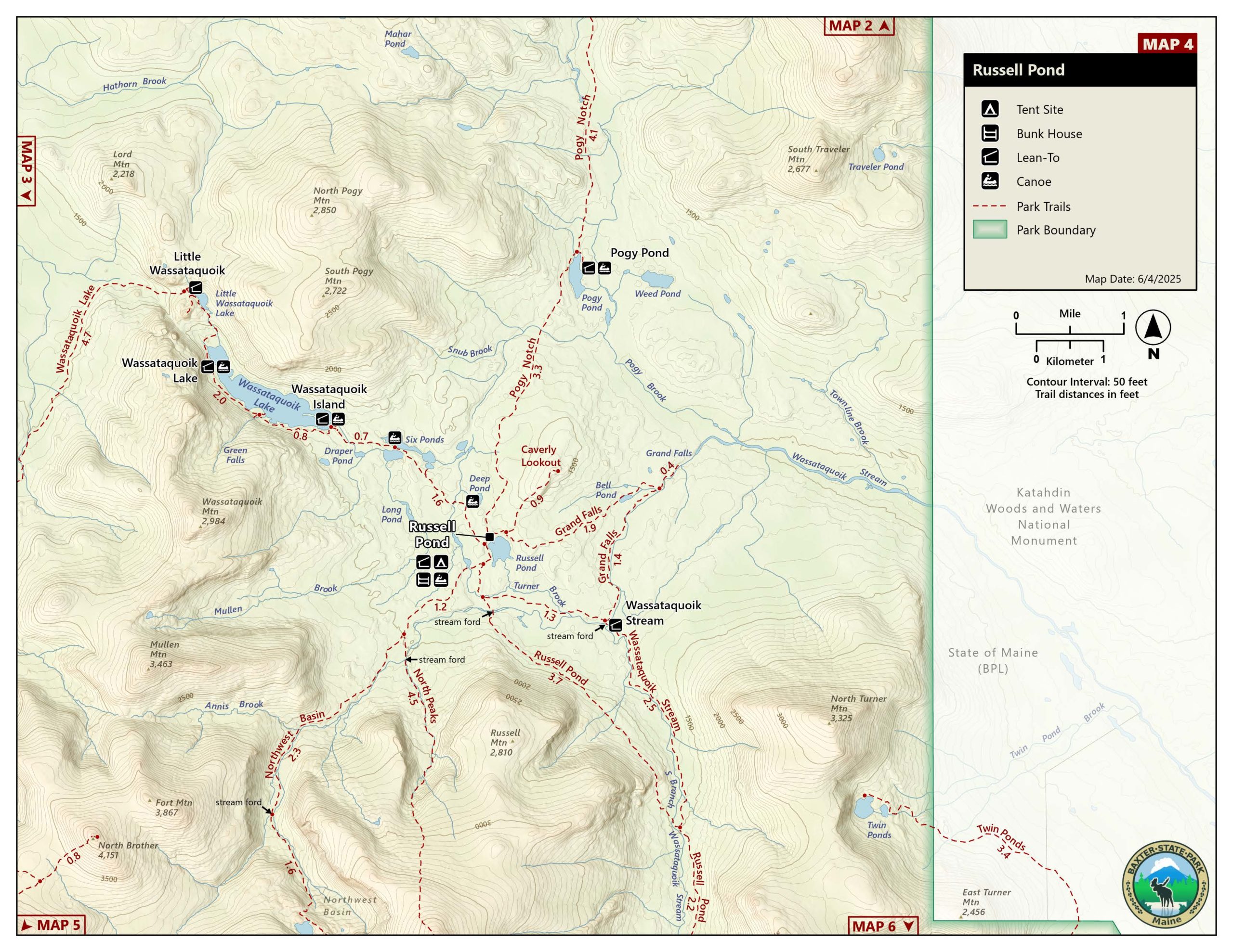
- Roaring Brook Campground, accessing Chimney Pond (connecting to Dudley, Cathedral, Saddle, and Hamlin Ridge), Helon Taylor, Sandy Stream, South Turner Mountain, Russell Pond, and Roaring Brook Nature Trails
- Abol Campground, accessing the Abol Trail and Little Abol Falls Trail
- Katahdin Stream Campground, accessing the Hunt (Appalachian Trail) and Owl Trails
- Download a trail map
No other trailheads in the Park require a KTP- they are filled on a first-come first-served basis.
How do I get a KTP?
- Starting on April 1 you can reserve KTP’s in advance for any day of the summer (online, by phone, or in person at our reservations office).
- There is a limit of 2 KTP reservations per calendar month for the months of June-October. KTPs are not required in May.
All KTP sales are non-refundable/non-transferable.
When can I enter the Park with a KTP?
- If you have reserved your KTP in advance, you may enter the Park to travel to the trailhead specified by your KTP when the Togue Pond Gate opens at 6 a.m. On busy summer days you can expect to wait in line at the gate with other KTP holders. Please bring a printed copy of your KTP to help the line move more quickly.
- Your KTP expires if you are not in the KTP line at the Togue Pond Gate by 7 a.m. on the day of your hike. After 7 a.m. (and once all KTP holders have entered), you forfeit the reserved spot and it is made available to other visitors on a first-come first-served basis.
When can I enter the Park without a KTP?
- If you wish to use a Katahdin Trailhead and don’t have a KTP, you may come to the Togue Pond Gate the morning of your hike. If spaces are available, you will be directed by staff to the line with KTP holders. If KTPs have all been reserved, you may wait in a first-come, first-served line that begins entering the Park after 7 a.m., (using reserved KTPs that have been forfeited). There are typically at least some forfeited KTPs each day.
- If you wish to visit another location in the Park (that does not require a KTP), you may enter the Park when the gates open at 6 a.m. If there is a line, you may join the line of KTP holders.
- For those wishing to only visit Sandy Stream Pond from the Roaring Brook Campground Parking, you may inquire at the gate for a “Moose Pass”. A limited number of these passes allow visitors interested in observing wildlife at Sandy Stream Pond to park for the limited duration of 3 hours.
- If you have a reservation for a backcountry campground or backcountry campsite that is typically accessed from a Katahdin Trailhead (for example, if you are camping Russell Pond, you may park at Roaring Brook in the morning without a KTP). This exception only applies to those camping in the backcountry.
Since it’s implementation in 2010, the parking pass system has proven effective for achieving these goals. The procedures and policies associated with parking passes have— and will continue to—evolve in response to changing park use demands and with new or improved technologies that enable more fair access and a user-friendly process for Park visitors.

Except for Katahdin access parking lots under the parking reservation system, all other parking lots are first come first served.
Reservation Office 207-723-5140
Winter M-F, 8am-4pm | Summer 7 days/week, 8am-4pm
Office hours are subject to change without notice.